Cities Are Booming and the Climate Is Warming. What Does That Mean for Humanity?
Columbia postdoc Cascade Tuholske builds maps to understand how humans interact with our environment. He spoke with Columbia News about what can be learned from large-scale data, how he copes with climate dread, and why he thinks the U.S. Constitution should guarantee the right to food.

Cascade Tuholske is a postdoc at Columbia’s hub for all things map-related, the Center for International Earth Science Information Network (CIESIN) at the Columbia Climate School. CIESIN builds software and big data sets aimed at understanding how humans interact with our environment. Tuholske grew up in Montana, where cows outnumber people, but cities have long held his fascination. “In any new city, I enjoy putting my headphones on, picking a place on the map, and spending the day wandering there,” he said.

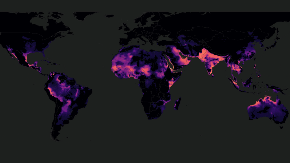
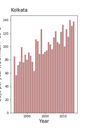
Now based in New York, a city built for wandering, Tuholske has explored how a combination of climate change, population growth, and the urban heat island effect is exposing more people to dangerous extreme heat. As world leaders meet in Glasgow to address the climate crisis, Tuholske said he’s hopeful that they will agree to aggressive targets for cutting carbon emissions. “We have the money and the tools to help the billions of people already impacted by climate change,” he said. “We just need to do it.” Columbia News caught up with Tuholske days after he received a NASA early career grant to continue studying extreme heat and land-use change.

What should people understand about climate change and urbanization?
Climate change poses vast and complex challenges for cities worldwide. But we have the tools to adapt if we can understand the demographics on the ground. Who is moving to cities? What do they do for work? Do they have enough to eat? For billions of people on the planet, we have no idea. Thankfully, we’re starting to get answers by mapping settlements and migration patterns through projects like GRID3 and the Groundswell Report, both of which CIESIN has contributed to.
Most of the world’s great cities are located on water, where most sewage wastewater winds up. What have you learned about its impact on marine ecosystems?
Our shift to animal-based protein diets is having a huge impact on coastal ecosystems worldwide because of sewage wastewater. That’s the main conclusion of a study we have coming out this month. Animal based foods are super high in nitrogen, and most wastewater treatment plants are designed to remove pathogens, not nitrogen. The more burgers we eat, the more nitrogen we poop. Nitrogen harms marine life by feeding plant growth and toxic algae blooms that limit the amount of oxygen available to fish and other animals.
Our research shows that nitrogen from wastewater now accounts for a huge portion of the nitrogen we’re putting into coastal waters. Much of this comes from coastal megacities or cities on large rivers like the Danube, Ganges-Brahmaputra, and Yangtze. Tourism in small coastal communities can also have an outsize impact on watersheds in the tropics and near coral reefs, too. Who knew our poop was killing corals?
More people are struggling with anxiety about climate change. You recently wrote for Outside magazine about your own climate dread. Any advice for those of us also feeling helpless and depressed?
The challenges are very real and very scary. To quote the Lord of the Rings wizard, Gandalf: "All we have to decide is what to do with the time that is given us." As someone with immense economic and cultural privilege, I try to wake up each day ready to work hard, and to be kind, empathetic, and deliberate in my actions. We have the resources to mitigate and adapt to climate change. But those of us with privilege and power have the greatest responsibility to act and pressure our leaders to do the same.
How did you get interested in maps and visualizing big data sets?
As a kid, I had a Time magazine issue on geography with which I would plot imaginary travels across the planet. By high school, I was fixated on global politics, especially oil politics in the Middle East. Studying international affairs at George Washington University, I became worried that oil money would obstruct efforts to mitigate climate change. By the end of college, I was spending hours flying around Google Earth where it was easy to visualize how oil politics, population movements, and climate change intersected. I realized that I might be able to make a greater impact on policymaking as a scientist than as a staffer on Capitol Hill or at an NGO. I ended up in a PhD program in geography at the University of California, Santa Barbara, returning to my childhood fascination with maps.
Advice for anyone going into geography and data science?
You can do it! Seriously. I didn’t learn how to enter data into Excel until my second semester of graduate school at UC Santa Barbara. I had never written a line of code or used a Geographic Information System (GIS) or Linux shell prompt. Now I write code nearly every day.
Anyone can learn these tools, and most geospatial coders are very willing to teach others. There are so many great, free resources online. If you’re in high school, I’d recommend getting a degree in geography. Many U.S. colleges have excellent programs, and the job prospects are rad: from government to tech to climate-change science. Even Tinder needs geographers and GIS experts.
If you could get your hands on any dataset, what would it be?
A high-resolution global map of poverty. Many have tried to create a map like this, with varying success. Right now, we simply don’t know at a neighborhood or building-level scale how many vulnerable people there are worldwide, and where they live, especially in cities.
What’s the most important discovery you’ve made by visualizing data at scale?
Integrating satellite observations of Earth with measurements on the ground are producing lots of new insights. Our recent paper on extreme heat exposure would not have been possible without two datasets of this type: the high-resolution CHIRTS-daily temperature dataset and the human settlement dataset that CIESIN contributes to, Global Human Settlement Layer (GHSL). GHSL matches census data with the built footprint of human settlements as seen by satellites.
Similarly, we can also combine satellite and weather station data to better estimate temperature shifts on the ground. Some 4 billion people live more than 25 kilometers from a weather station so satellites help to fill in critical gaps on our maps of Earth’s changing climate and population. In a recent article, we explain why satellite data is so important for monitoring, anticipating, and adapting to extreme heat in a warming climate.
What’s the most important takeaway from your class last spring, “Threats to Urban Food Security: Climate, Cost, & COVID” co-taught with former Columbia postdoc Weston Anderson?
If the U.S. Constitution guaranteed a right to food, we'd live in a much more equitable country. So many families struggle to put food on the table, but too many politicians are indifferent. Our class readings focused on how political and economic systems influenced by racism and classism are at fault. We don’t value the right to food in the same way we value the right to free speech, to vote, or to bear arms. If our goal as a country was to end hunger today, we could do it, not just here, but around the world. The first step would be to enshrine a right to food in our constitution. You can learn about the right to food in this 2013 paper by Molly Anderson.